


US Topo Maps
Perihal US Topo Maps
Mudah untuk menggunakan aplikasi navigasi luar dengan akses percuma kepada peta terbaik yang tersedia dan imejan udara untuk AS.
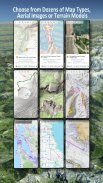
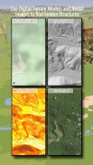
Pilih antara 30+ lapisan peta (topos, aerial, carta laut, ...) untuk merancang perjalanan yang sempurna dan
jadikan Telefon/Tablet Andoid anda menjadi GPS luar untuk perjalanan luar talian ke kawasan pedalaman.
Tambahkan peta dengan mudah daripada sumber lain (GeoPDF, GeoTiff, Perkhidmatan Peta Dalam Talian seperti WMS, ...)
Lapisan peta asas yang tersedia untuk AS:
• Topo Peta Negara USGS
• Topo Imejan Peta Negara USGS
• Imejan Peta Negara USGS
• Imejan USGS NAIP HiRes
• DRG tradisional USGS Topo: Liputan lancar peta topo AS pada Skala 1:250.000, 1:100.000, 1:63.000 dan 1:24.000/25.000
• Peta Hutan FSTopo
• Carta RNC Nautika NOAA
• Peta Ketinggian Kebangsaan (Hillshade, Peta Cerun, Peta Aspek)
Lapisan peta asas seluruh dunia:
• OpenStreetMaps (5 susun atur peta berbeza), juga boleh dimuat turun dalam format vektor penjimatan ruang
• Peta Google (Imej satelit, Peta Jalan dan Rupa bumi)
• Peta Bing (Imej satelit, Peta Jalan)
• Bumi Pada Waktu Malam
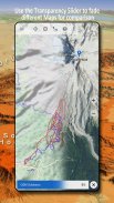
Konfigurasikan lapisan peta asas sebagai tindanan dan gunakan pemudar ketelusan untuk membandingkan peta dengan lancar antara satu sama lain.
Tambahkan peta daripada sumber lain:
• Import peta raster dalam GeoPDF, GeoTiff, MBTiles atau Ozi (Oziexplorer OZF2 & OZF3)
• Tambah perkhidmatan pemetaan web sebagai WMS atau WMTS/Tileserver
• Import OpenStreetMaps dalam Vectorformat, cth lengkapkan USA untuk beberapa GB sahaja
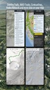
Tindanan peta AS yang tersedia - tambah maklumat tambahan pada mana-mana peta asas lain:
• Pemilikan Tanah Awam (PAD-US 3)
• Set Data Hidrografi Kebangsaan
• Peta Penggunaan Kenderaan Bermotor (USDA)
• Garis Kontur Ketinggian
• Laluan 4WD
• Laluan
• Jalan Raya, Kereta Api, Lapangan Terbang
Lapisan yang tersedia di seluruh dunia:
• Tindanan teduhan bukit
• Garis Kontur 20m
• OpenSeaMap
Tiada peta yang sempurna. Togol antara lapisan peta yang berbeza atau gunakan ciri bandingkan peta untuk mencari laluan yang paling menarik. Terutamanya DRG tradisional lama mengandungi banyak laluan kecil atau ciri lain yang tiada pada peta moden.
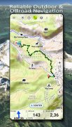
Ciri utama untuk navigasi luar:
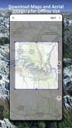
• Muat turun data peta untuk PENGGUNAAN LUAR TALIAN
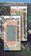
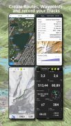
• Ukur laluan dan area
• Buat dan edit Titik Jalan
• GoTo-Waypoint-Navigation
• Buat dan edit Laluan
• Navigasi Laluan (Navigasi Titik-ke-Titik)
• Rakaman Jejak (dengan profil kelajuan, ketinggian dan ketepatan)
• Tripmaster dengan medan untuk odometer, kelajuan purata, bearing, ketinggian, dsb.
• GPX/KML/KMZ Import/Eksport
• Carian (nama tempat, POI, jalan)
• Dapatkan ketinggian dan jarak
• Medan data boleh disesuaikan dalam Paparan Peta dan Tripmaster (cth. Kelajuan, Jarak, Kompas, ...)
• Kongsi Titik Jalan, Laluan atau Laluan (melalui e-mel, Dropbox, WhatsApp, ..)
• Gunakan koordinat dalam WGS84, UTM atau MGRS/USNG (Military Grid/ US National Grid),
• Main Semula Trek
• dan banyak lagi ...
Gunakan apl navigasi ini untuk aktiviti luar seperti mendaki, berbasikal, berkhemah, mendaki, menunggang, bermain ski, berkanu, memburu, lawatan kereta salji, lawatan 4WD luar jalan atau mencari&menyelamat (SAR).
Tambahkan titik laluan tersuai dalam format longitud/latitud, UTM atau MGRS/USNG dengan datum WGS84.
Import/Eksport/Kongsi GPS-Waypoints/Tracks/Routes dalam format GPX atau Google Earth KML/KMZ.
Lihat radar hujan NEXRAD animasi untuk membuat ramalan yang tepat apabila hujan akan mula/berhenti
Sila hantar soalan, komen dan permintaan ciri ke support@atlogis.com
US Topo Maps - Versi 7.7.0
(19-02-2025)US Topo Maps - Maklumat APK
Versi APK: 7.7.0Pakej: com.atlogis.northamerica.freeVersi Terkini US Topo Maps
Versi lain


Aplikasi dalam kategori sama


